The Petaluma Watershed
A Watershed is "that area of land, a bounded hydrologic system, within which all living things are inextricably linked by their common water course and where, as humans settled, simple logic demanded that they become part of a community."
- John Wesley Powell
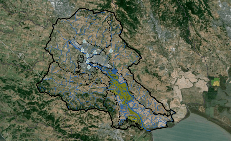
PETALUMA WATERSHED OVERVIEW
146 Square Miles (~19 m x ~13 m)
Highest Peak Elevation = 2,295 ft
11% of watershed is Salt Marsh
Over 5,000 acres -surrounded by 7,000 acres of reclaimed wetlands
The Single Largest and Least Disturbed example of Ancient Tidal Marshland in California!

Watershed Atlas
The Petaluma Watershed Atlas is an interactive map for the community to explore watershed-focused features of interest like sub-watershed boundaries, access points, and conservation and development projects. Friends of the Petaluma River partnered with ECON, a leader in the field of geology, the Sonoma County Water Agency, the City of Petaluma and the Sonoma Resource Conservation District to produce this ideal resource to navigate the Petaluma Watershed.

Watershed Timeline
Take a walk through time in the Petaluma Watershed. Our interactive Watershed Timeline leads you through a graphic and informative narrative of important historical events that have impacted the Petaluma Watershed. Crafted with historians from the Sonoma County Library we have put together a resource to explore the interactions and impacts of the greater world and the Petaluma Watershed from its first inhabitants to modern day development.

Key Terms & Concepts Guide - Coming Soon
What everyone should know about a watershed plus facts and details about the Petaluma Waterhsed. Test your Watershed vocabulary, discover how a watershed works and find out what makes our Watershed so special. Our guide will answer everything you've ever wanted to know about a Watershed.